


📅 Thursday 27th August 2026 | 🕐 10:30 –16:00
📍Hybrid: Cardiff University | Sir Martin Evans Building | BIOSCI – SMEB C124 Boardroom & Online
🔗Click here to register for the Earth Observation Knowledge Exchange Event
Many thanks for expressing an interest in attending a Planet Labs Earth Observation Data Knowledge exchange event. We hope you can attend on Thursday 27th August 2026.
We would welcome additional flash talks to find out more about how Earth Observation data is being used across Wales.
Proposed schedule
10:30 – 11:00 – Registration, coffee and networking
11:00 – 12:30 – Welcome.
- Brief Introduction to Environment Platform Wales
- Welsh Government Earth Observation Program Update
- Rosie Cane | Space Wales | Connecting Wales Through Earth Observation and Space Innovation
12:30 – 13:30 – Flash presentations:
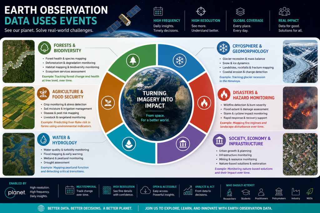
- Ben Clarke | Aberystwyth University | Identifying fire regime history and critical transitions in peatland functioning in Wales.
- Adetoun Afolabi | Swansea University | Nature-based solutions
- Mykola Kutia | Bangor University | Forest cover dynamics and ecosystem services quantitative analysis using high spatial resolution satellite imagery.
- Saman Sobhani | Aberystwyth University | Monitoring and Scenario Modelling for Sustainable Urban Green Space Management in Cardiff city.
- Additional Flash Presentations welcome
- Discussion on how you are currently using / considering to use Earth Observation Data in your research
13:30 – 14:30 – Lunch and Networking
14:30 – 15:00 – Juan Suarez | Swansea University | Multitemporal Random Forest Classification of Forest Tree Species Using PlanetScope Imagery
15:00 – 15:45 – Aidan O’Donnell | Cardiff University | Use of data at Cardiff University’s School of Journalism
- Discussion on use of Earth Observation data in teaching & barriers to integration with curriculum.
15:45 – 16:00 – Wrap-up
| Rosie Cane | Presentation on Space Wales: Connecting Wales Through Earth Observation and Space Innovation This presentation will provide an overview of Space Wales and its role in supporting the growth of Wales’ space sector through collaboration between industry, academia and government. It will highlight how Earth Observation is contributing to environmental monitoring, sustainability and innovation across Wales, and outline opportunities for partnership, funding and future engagement within the Welsh space ecosystem. |
| Juan Suarez | Presentation on: Multitemporal Random Forest Classification of Forest Tree Species Using PlanetScope Imagery This research investigates the use of multi-season PlanetScope surface-reflectance imagery and Random Forest classification to identify commercially important tree species in Thetford and Aberfoyle forests. This method of classification explores the phenological differences between tree species as the ground for classification. The method develops spectral-band and vegetation-index predictors, derives training data from field-verified pure stands, and applies forward feature selection to refine the model. To address spatial autocorrelation and avoid inflated accuracy estimates, the study employs spatial block cross-validation alongside conventional training and validation splits. The resulting classifications demonstrate strong species-level discrimination, indicating that multitemporal remote sensing, combined with carefully selected predictors and spatially robust evaluation, offers an effective approach for forest species mapping and sustainable management. |